Groundhogs Day was just the other day, and it got me thinking about just how early do those people in their suits and hats start hitting the bottle anyway? I imagine you would have to be quite snockered to stick your hand in a groundhog burrow, drag him out, and parade the poor li’l critter around. If you tried that in East Tennessee, someone would be groundhog bitten— seriously! And who could blame them? I imagine if I were a groundhog, or any kind of hibernating creature, I would bite the hell out of somebody if they woke me up when there is still snow on the ground. The furry li’l varmints here didn’t even wake up, roll over, and as much as poke their noses out of their burrows–and why should they? It is still winter. There isn’t any sweet clover or acorns to eat. Go back to sleep, ‘Puxatony Phil’…
Indeed, it is still winter, and the mountains here are covered in snow right now, and a couple of days ago when I started to write this (Groundhogs Day) the clouds were so thick on the mountains that they were completely buried beneath them and I couldn’t even see the closest one. It is very scenic, however, if you can get up into the mountains, but that can be a bit of a problem; and with the intermittent melting snow waters, rain and more snow, the creeks and waterfalls are moving at a fairly high volume. With that in mind, my trail hiking buddy, ‘Rat Patrol’, wanted to hike out to a few of them and take photographs.
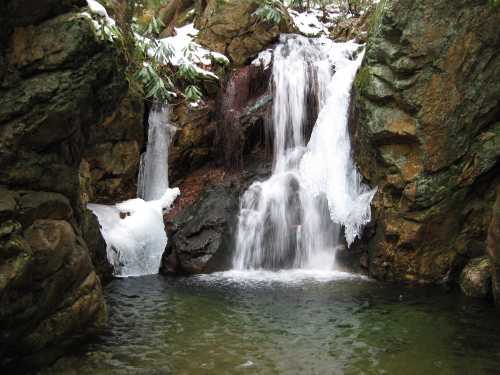
The first ‘waterfall hike’ was a 5 1/2 mile trek out to Dick Creek Falls on Unaka Mountain and back. It had been over 20 years since the last time I had visited those falls; I used to camp near there in the summertime with friends, and swim in the cold pool of water beneath the falls–that was very refreshing, as I recall–but I wasn’t very tempted to jump in on the mid-January Saturday afternoon while we were there. The weather was quite cool, and there was a layer of slushy snow in the trail from Rock Creek Park, where ‘Rat Patrol’, his son Tyler, and myself began our hike, all the way through Dick Creek Gap, beyond the ‘Rattlesnake Ridge’ trail, and to the well-hidden waterfall. We had met a couple of friendly hikers on the way who were on their way back from the falls, so it was easy to follow their boot tracks in the snow, and avoid getting lost. The falls are not very tall, only 22 feet, but they are pretty attractive, especially with a healthy flow of water plunging off the top and ice clinging to the sides. On the way back we (inadvertently) decided to hike up the Rattlesnake Ridge Trail for a little while before returning to Rock Creek Park.
The next ‘waterfall hike’ was to the ‘Rock Creek Falls’—two impressive 50-footers on Unaka Mountain. Although there are other – falls on that network of streams, these seem to be the largest and most visited ones. Indeed, on the day we hiked up there, the entire creek looked like a cascading waterfall. Again, it was ‘Rat Patrol’, Tyler, and myself, hiking out of Rock Creek Park for a 5 mile, round trip, hike; the weather was cold and quite windy. There were several creek crossings we had to negotiate, which weren’t very easy because of the depth of the water, and we had to do some log-walking in places (I actually fell in on the way back). We also ran into the same friendly hikers we had met the week before…again returning from the falls to which we were going. The falls themselves were remarkable, if not spectacular, with much water flowing off the tops, and ice clinging to the cliff walls nearby.
After that trek, I decided to go out for a solo hike into the Sampson Wilderness one afternoon. The plan was to hike up the Big Pine Ridge Knob—the one we have nicknamed ‘The Volcano’—and then out the narrow ‘land-bridge’ to the next knob on Big Pine Ridge, the one we call ‘The Pyramid’. From there, I could either find a way down into either Sill Branch or Devil’s Fork, or continue hiking up the ridge beyond the cliffs that overlook the Devil’s Fork until I reached the old roadbed that connects with Sill Branch to the left and the road to Bearwallow Gap on the right.
It was another ‘extreme’ hike for me; while the weather was sunny, and a little bit cool, the trail was extremely rough, if not non-existent and very steep in places. For long stretches at a time, with every step I took, I was either stepping over, under, or around some logs, while plowing my way through the hardwood saplings that are growing in on top of that part of the ridge as thick as grass, it seemed. It was pretty frustrating, actually, as I kept tripping over blackened logs and getting swarped in the eyes and face with branches. Whatever trail used to be up there between the knobs is now completely buried in fallen logs, saplings and stickers.
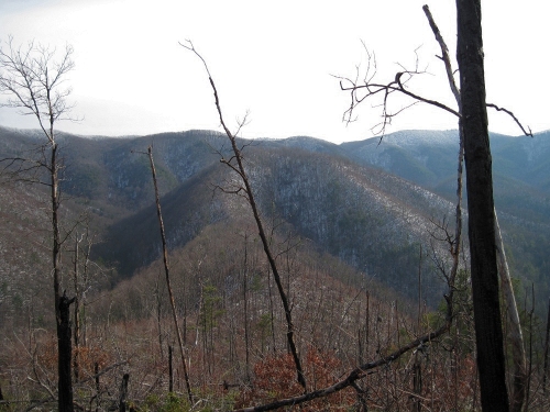
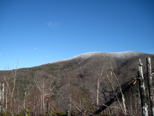
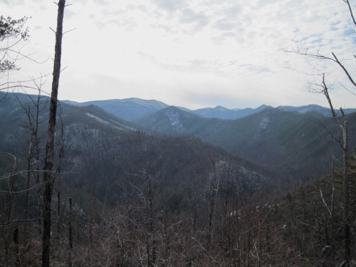
The hike didn’t start out too bad, having parked at the Sill Branch trailhead, but I had to really pace myself to get to the top of ‘The Volcano’ because of the sharp inclination from the Sill Branch side, but I gained quite a bit of altitude in only a half mile, or so. The views from the top were very good, since I had a direct line of sight to the Sill Branch Overlook, the Sill Branch Valley, Devil’s fork, Longarm Ridge, the Longarm Valley, and I could even see over the top of the Longarm Ridge to view much of Sampson Mountain. The trail over the narrow ‘land-bridge’, the connecting piece of mountain between the knobs, was as I described before, and by the time I reached the top of ‘The Pyramid’ I was very tired, and considering dropping back down into Sill Branch where I would come down right where the right fork splits again. However, the moon was just rising over the ‘Meatgrinder Ridge’ and I could see the cliffs that overlook Devil’s Fork just up the Big Pine Ridge a ways, and having never stood on top of them, I was very tempted to continue on to them (I didn’t get the ‘Boulderman’ name by sniffing daisies, you know).
Standing in the snow at the very edge of the cliffs overlooking Devil’s Fork is not the safest thing I have ever done, as one slip there could have been my last, and it is quite possible that no one would ever find me. I was careful, though, if not just a little bit scared, and could look right down into the impressive Devil’s Fork Valley where so many cascading creeks and waterfalls reside. Some people think that I am crazy, risking my life to take photos from rocky cliffs and such, but when you think about how many people slip, fall and subsequently die in their bathtubs every year, it is a risk that I am willing to take, experiencing what is left of the wilderness and enjoying the divine natural world while I still can.
In the end, despite being exhausted, I finished climbing the ridge to the old roadbed and followed some coyote tracks in the snow back to the south fork of Sill Branch. From there, I followed the steep trail down, arriving back at the car just about dark. It was a rough 6 mile hike, but worth the effort, I believe.
The very next day, my trail-hiking buddy ‘Rat Patrol’ called me wanting to go take more waterfall photos. I was still tired and sore from the previous day’s hike, so I suggested that we go to ‘Red Fork Falls’ on Unaka Mountain. Red Fork is a very impressive 100 foot waterfall when the water levels are up, like they are right now, and the trail down to them isn’t very far. It is a bit steep, however, and quite slippery when the rocks are wet or iced over, so we proceeded with caution down to the bottom of the falls. The water shooting off of the top was extraordinary, forming a large ‘rooster tail’ as it fell to the rocks below, churning in the deep pool at the bottom, and the sound of the water was so loud, I could not even hear what Rat was saying from only a few yards away. There are more falls and cascades along the ‘Red Fork’ stream, both above and below the main falls, and they all were kicking butt that day! It was a fun, and rewarding hike.
More adventures soon, I hope…
~~~~~~~~~~~~~~~~~~~~~~~~~Boulderman


[…] by way of the Rock Creek Recreation Area on Unaka Mountain (perhaps I mentioned this in a previous blog). Dave and his friend, Lou, were actually on their way back from these secluded waterfalls, which […]