It has been quite a while since I have uploaded a new trail-blog, which is unfortunate, and I apologize, but please note that I have been very busy and have not given up on either hiking or blogging. While I am way behind in chronicling my hikes, I do hope to get caught up eventually. While it doesn’t take very long to write a trail blog (unless you lose your notes, like I did… and having the pc fried by lightning didn’t help either), sorting through, resizing, and uploading the photos rather does, so I may not go too much ‘in depth’ like I usually do, but I will try and give a good report, never-the-less.
Margarette Falls…
In mid-January, I was contacted by waterfall enthusiast and aficionado, Dave Aldridge; he had been studying maps and making plans to find the ‘Bailey Falls’ in Greene County, and asked if I could go along. As it turned out, I wasn’t busy that day, and having never been to Bailey Falls, decided to hike with him in an attempt to find them. We drove to the trail-head just beyond the old ‘Shelton Mission’ about mid-morning of the 20th, and began our quest, hiking up the cold creek trail into ‘Bullen Hollow’. As I just mentioned, it was a chilly morning, particularly in the mountain hollow, and there was still quite a lot of snow and ice in the trail and along the creek-banks. Even so, quite a lot of the snow had melted down over the previous couple of days, and the cumulative snow-melt had made the water-level and overall flow of the creek rather substantial, making every cascade along the way appear like a waterfall unto itself.

Margarette Falls
Dave, a retired engineer, had brought along his new hypsometer, and was measuring the heights of any significant cascade, waterfall, or cliff-ledge (there were several of each) all the way up the hollow. Before we had gotten too far, however, we encountered three gentlemen from the National Forest Service, who were working, putting the finishing touches on the new pedestrian bridge that spans the creek in a place that appears to be vulnerable to flooding, making it much easier to access the upper part of the ‘Margarette Falls Trail‘ (‘Bailey Falls’, as it turns out, is well beyond the Margarette Falls). Anyway, Dave, among his many talents, is a gifted conversationalist, and having known and worked with a few of their colleagues, took a few minutes to tell a few jokes, while I admired the new fiberglass bridge.

Margarette Falls (from above)
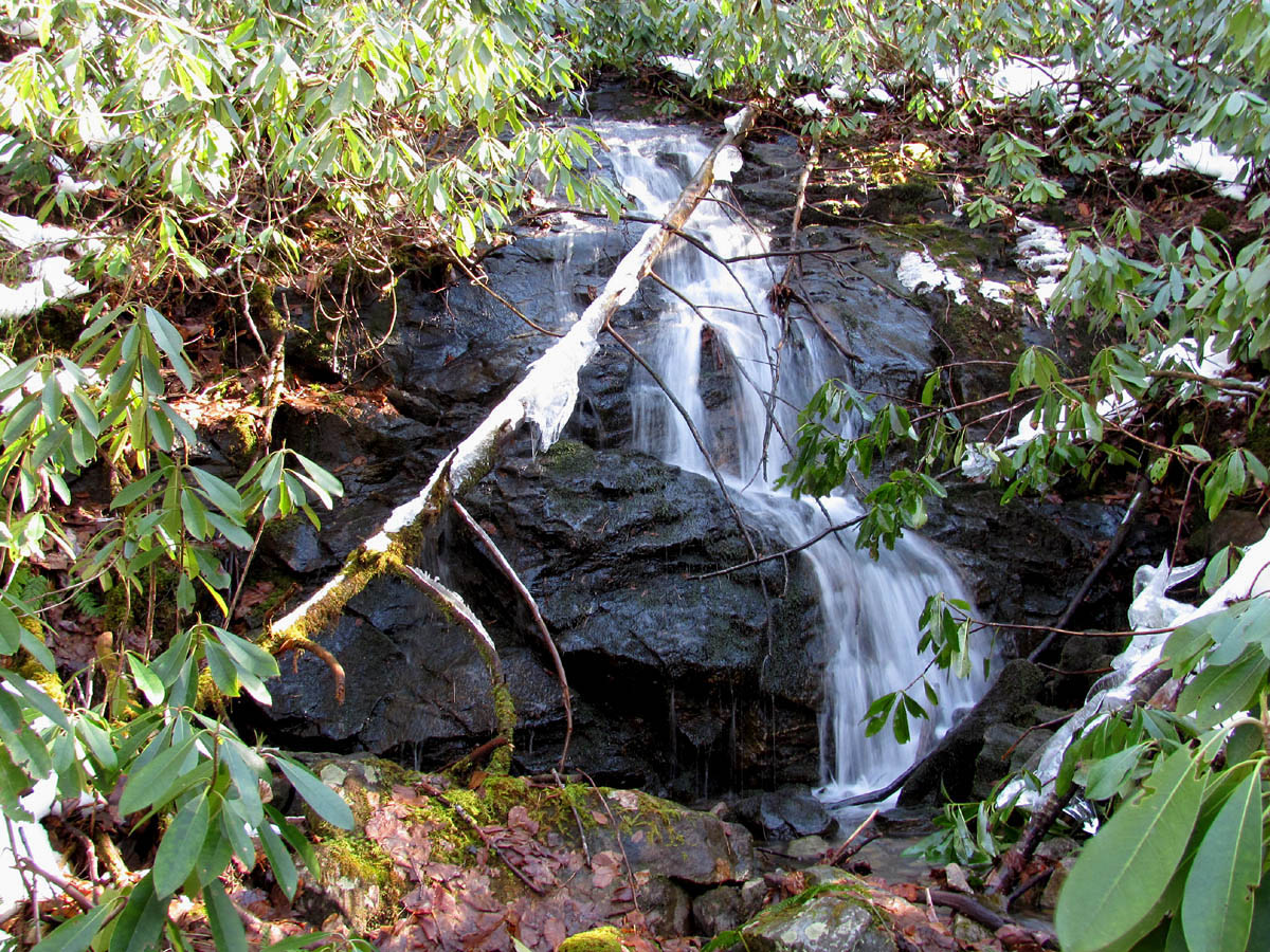
The trail beyond the bridge was quite slippery, but the raging creek was inspirational, with several small waterfalls and many nice cascades to admire as we continued on up the snowy creek trail that skirts below sheer cliff faces, some over 200 feet tall. As fascinating as all the small falls and cascades had been, they all paled in comparison to the ‘mighty’ Margarette Falls. What with all the significant snow-melt waters arching and plummeting over the top-edge (Dave calculated the actual height at 68 ½ feet tall) and the way a good quantity of that water was somehow funneled along the length of several rock-ledges on the pathway down, and falling again, spreading the water out darn near as wide as the falls are tall, gave the Margarette Falls a beautiful appearance. I was really impressed.

Cascades along the Margarette Falls Trail
Dave and I took a short lunch break here, soaking in the beauty, while the cold wind from the waterfall quickly chilled us down after our mile and a half hike to get there. I was still entranced by the falls, taking photos (and ultimately a video) and such, when I noticed Dave climbing a steep and rocky path (you couldn’t really call it a ‘trail’) that was leading up the right side of the falls. I caught up to him pretty quickly, and we continued on up beyond a prominent rock ledge, and after climbing over this solid stone obstacle, made our way back to the left, to the top of the Margarette Falls. What we couldn’t see from below was the long cascading ‘rock-chute’ that quickly funneled water down, feeding a small 10’ falls that was just before the main fall. The rocks were much too icy and slippery to stand upon the top of the falls, although I did find a perch above that had a similar view. Moving around the rock-chute and the top of the falls was kind of dangerous, given the icy conditions, but we were cautious.

Cascades Along the Margarette Falls Trail
Dave and I contemplated our next move, which tested our determination, and will to find the elusive Bailey Falls. Inevitably, we decided to risk a slippery creek-crossing over a particularly icy, mossy, and extremely slick boulder in the creek just above the rock-chute and the fast moving stream of water. We climbed up a steep hillside and maneuvered around beneath some fractured rock ledges, and made our way up the remarkably narrow creek-valley to what we thought were ‘Glen Falls’, which was where a tributary-creek joined the main creek from the opposite side of the Bullen Hollow. According to the map and the information we had, Glen Falls was only supposed to be 8-foot tall, but with the raging ‘white-water’ snow-melt flooding down the mountain, the cascades above seemed to definitely be part of the falls, and Dave (with his hypsometer) measured them at 28 feet tall. [Note: I have since learned that this cascade/waterfall is unnamed, and is not ‘Glen Falls’, which is further upstream, apparently.]

Cascades above Margarette Falls
From here, the creek-valley narrowed down even more, being only about the width of a one lane country road with rock cliffs on either side. Judging by the map, we were within about a 10th of a mile from Bailey Falls; however, it appeared, what with the wider (and deeper) than usual creek, we would have to wade through the cold water to get there. My feet were already fairly wet, but Dave’s feet had somehow remained dry, and the thought of wading through the icy waters, and walking back down the waterfalls and the trail with cold, wet feet made Dave cringe, so we decided to turn around and perhaps come back one day with extra socks and shoes.

Creek Along the Margarette Falls Trail
With some difficulty, we climbed back along the fractured-rock wall, across the slippery creek-boulder, and back to the top of Margarette Falls. From there we cautiously made our way back down the slippery rock pathway to the base of the incredible Margarette Falls. We took another snack break here in the cold mist and wind, admiring the beauty of the waterfalls and the way they contrasted with the tall, rugged cliffs that towered above us.

Cliffs near Margarette Falls
On our way back to the car, we encountered (for the 2nd time) the Forest Service people still working on the bridge, and (after Dave conversed for a while longer) helped carry a couple of buckets of tools back to their tram-like transport vehicle with a large wheel barrow-like bucket on it. Back at the car, we had no regrets, despite not quite getting to ‘Bailey Falls,’ and I considered it a surprisingly impressive adventure.
Devils Creek (part one)
I had been wanting to go see the waterfalls on Devils Creek for quite some time; it had been over 20 years since the last time–which was also the first and only time—I had seen them. When I mentioned my plan to visit the falls on Devils Creek to my hiking buddy, ‘Rat Patrol’, and he also became inspired to see them, so we began planning an expedition.
It is not very well known that Devils Creek (sometimes called ‘Stateline Creek’, since it is the border between North Carolina and Tennessee for a significant stretch up that steep, cliff-lined valley) has some very nice waterfalls and cascades, along with a couple of deep pools near the entrance to the valley. It seems to me that we (our hiking club back then) found them by accident one time on our way hiking back from ‘Lost Cove’. I sort of assumed that no one ever spoke of them because the river rafters, kayakers, and canoeists wanted to keep them secret for their own personal swimming pool usage in the summertime, but now I also think that the reason why they are seldom seen or spoken about is because of the railroad, which runs up and down the river gorge; they probably don’t want a lot of people walking the 2+-mile stretch up the tracks, because it is somewhat dangerous..

Mossy Rock
Our plan, however, which was flawed, (okay, it was my plan) was to avoid the train tracks by accessing the Devils Creek Valley from above, descending from the ridge-top on an old logging road near Devils Creek Gap that I had found on a previous adventure. The problem with ‘the plan’ was that the Forest Service road that leads into Devils Creek Gap was buried in snow and is closed during the winter, which meant we had to walk an extra 2.1 miles of trail from Spivey Gap just to get to Devils Creek Gap (which we could normally drive to). On top of that, we had gotten a late start, and didn’t even set a boot upon the snowy trail until nearly 11 a.m. On the plus side, the snow was hard and crunchy, which made for good traction for boot-treads, and we were determined to have fun hiking the trails, regardless.

Swampy Area Along the Appalachian Trail
Anyway, to make a very long story a bit shorter, we hiked way down into the Devils Creek Valley, and made some interesting discoveries in regards to the creek and the mountains, including a long cascade that disappeared into the laurel thickets of the steep mountain hillside. The trail became very rough, if not non-existent, after awhile, and we had to make our trail through the snow, following the path of least resistance. There were some places we encountered where the snow was over knee deep, and there were a few times where we stepped into a snow-filled crevice and fell, and we suffered a few shin bruises as a result.
Long Cascade found in Upper Devils Creek (photo by RAT)
In the end, we weren’t able to reach the big waterfalls near the river, because we began to run out of daylight. We realized this while taking a break beside some nice cascades along the creek, a few yards away from a place where some bears (difficult to believe that they were out and about already, but that valley is a bear reserve) had stomped and wallowed around in the snow. We could not have been very far above the waterfalls we had hiked down to see, but since we didn’t leave a 2nd vehicle in Chestoa, we had very little choice but to abandon our quest, for the time being, and traverse back to Spivey Gap. The extra 2.1 miles of trail (4.2 actually, since we had to hike back over it again to get to the car at Spivey Gap) was just too much to overcome and still be able to view the waterfalls near the river.

Upper Devils Creek
It was a long, steep climb back to the top of the ridgeline, and the Sun was already sinking low on the horizon before we even made it back to Devils Fork Gap. We were getting rather tired, but made it back in time to get a good view of Little Bald Mountain, Whistling Gap, and High Rocks (a wonder in itself, since it usually stays well hidden among the mountains) from the ridge-top trail on Flattop Mountain, as well as a very inspiring view of the Sun setting behind the ‘Hogback’ Ridges, with Viking Mountain and Coldspring Mountain well off to our right. The last mile and a half, or so, was achieved in the dark over some very slushy, snow-slippery trail. We ended up hiking approximately 9 miles, a good portion of that was over some very rough trail.

Cascades along Upper Devils Creek
While I was a little disappointed that we didn’t make it to the falls, I was pleased with the discoveries that we had made along the upper portions of the Devils Creek Valley and the lessons learned during the exploration. Also, the view of the Sunset from the Flattop Ridgeline was very inspiring, and made the adventure worth the effort after all.

Sunset from Flattop Ridge (photo by RAT)
Devils Creek Falls (part two)
8 days after the failed attempt to view the Devils Creek Falls along the North Carolina/ Tennessee border, I met up with ‘Rat Patrol’ about mid-morning, February 6th, for another try. This time, however, instead of walking in from the top of the valley, we chose a more direct route, following the train tracks up the Nolichucky Gorge. It is about a 2 mile rail-hike (perhaps a little further) to the Devils Creek Valley from the parking spot at Unaka Springs. Hiking up the tracks, we could see the valley from a long way off. We could also see many interesting rock-cliffs along the river gorge. We were fortunate, and didn’t have to dodge any trains on the hike in, and made it to Devils Creek in good time.

First set of falls and cascades on Lower Devils Creek

Rock Cliffs of the Devils Creek Valley
Immediately upon entering the valley, we were impressed by the cascades closest to the river. The water levels were up, partly because of the snow-melt waters still flowing off the mountain ridges. The further up the valley we went, the more waterfalls and cascades we encountered. They were more and more spectacular, it seemed, as we went, highlighted by a very impressive, twisted, double-waterfall below sheer rock cliffs, with a deep pool in between the two falls. We took a sandwich break right on top of the double-set of falls, admiring the scenic valley. We ventured a little further up the valley, despite the trail disappearing, and found another very pretty set of waterfalls. The light in the valley was getting rather dim by this time, and we decided to begin hiking back.

Double Falls on Devils Creek

Cascades found on Lower Devils Creek
We had to get off the tracks a couple of times and wait for a train to go by, but we still made it back to the car at Unaka Springs by twilight. It was nice to see the falls again after 20 years, the expedition was a huge success.
A Couple More Day-hikes…
I went hiking in the Laurel Fork Gorge in December; the creek was raging after all the recent rain and snow that we had had. The footbridges were covered with ice, and the footing along the trail, especially on the steep descents, was very slippery. The waterfalls, however, were quite fascinating, as a lot of water was being pushed over the top edge of the falls. I went on to the shelter, by the blue-blazed trail, receiving good views of the incredibly large rock-cliffs that are on the knob across from the waterfalls.

Laurel Falls
I also went on a day-hike in the ‘Old Forge’ area in February. Again, the water levels were high, and the waterfalls were nice to look upon. The wind was very intense that particular day, as I recall, pushing the trees darn near sideways as I walked below them. The creek crossings were difficult to maneuver, without getting wet, but this made for some impressive cascades up along the Jennings Creek. I encountered an owl sitting on a branch, but it flew away before I could get a photo.

Cascades on Jennings Creek

Waterfalls at Old Forge
Paw Paw…
The Appalachian Trail family lost an amazing fellow and friend in February. Affectionately known as ‘Paw Paw’ by his friends and family, Paw Paw was a true trail legend, and a inspiration to many of us who hike the trails. Not only had Paw Paw survived Pearl Harbor, World War II and the Korean conflict (he was wounded in that one), but he also hiked the entire length of the Appalachian Trail 3 times—the last time at the age of 83, which is nothing short of amazing. He was a very popular fellow, and I always looked forward to seeing him at ‘Trail Days’ in Damascus (Virginia). Good times always followed him around, it seemed. He was a credit to his country, and to the entire human race. So long Paw Paw, happy trails, my friend.

Alvis L. 'PawPaw' Kinney
~~~~~~~~boulderman 6-14-2011
[…] footbridge that had recently been constructed. I had heard about it in my friend Bol’Dar`s hiking blog, [trailstealth.com] as he had accompanied Dave on his last trip here back in January. After […]