Inspired by the trek up to Big Bald, and camping in the meadow above 5300-feet in elevation in July, I decided to embark upon another adventure for August. It had been 13 years since the last time I had hiked up Snowbird Mountain, just north of the Great Smoky National Park, and after much consideration, decided to go there anyway.
I have always considered the hill-climb off the Pigeon River up to the summit of Snowbird Mountain rather challenging. It is much easier to walk that section of trail from north to south, beginning at Max Patch, but never-the-less, I decided to park a car at Standing Bear Farm (on the gravel road that the Appalachian Trail crosses) about a mile from I-40, and the GSNP. I had heard rumors of rogue bears and closed trails in the park, and would have felt more comfortable with a trail partner; not only would it have been nice to have someone to talk to, but sharing equipment can lower pack weights significantly. But, since none were available, I found myself climbing that steep 5-mile hill alone, missing all my ‘Hairnt-fest’ trail-friends.
It was a warm day, in the low ’90’s, and quite humid. Having started just after the mid-day, it didn’t take very long to be soaked with sweat on the ascent up the mountain. My pack weighed in the mid to upper 40’s, and the first two miles wasn’t so bad and went pretty fast, as I was mostly running on adrenaline, excited to be on the start of another mountain adventure.
Not knowing how the springs were flowing up on top of the mountain, and having already consumed a quart, I elected to fill my water-bag with about a gallon of water from the stream at Painter Branch. I was beginning to feel like a sore-legged camel, however, feeling that the extra 8 lbs on the left side of my pack was just ‘too much’, putting my overall pack-weight in the mid-50’s range. There were several times that I thought about pouring it out, and probably should have, but having had to endure extreme droughts for the last several years, never quite sure where the next waterhole might be, I carried it all the way to my camp on top of Snowbird Mountain.
That mountain has always kicked my butt; apparently I forgot just how brutal that 5-miles hill was until hiking up it with about 54 lbs, or perhaps I just have a little more butt to kick these days, but that trail up Snowbird Mountain really kicked my butt. It was then I realized that I don’t really enjoy the ‘beast of burden’ feeling as much as I do the sitting around the camp, eating food and drinking coffee (or whatever). I realize that if you are reading this, you probably don’t care about how heavy the ‘boulder-bag’ was, but if you had been there with me, and had to carry it up that mountain, you would.
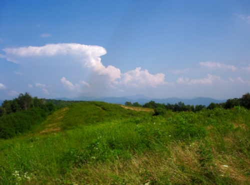
I eventually crested the first summit (elevation 4300 ft), getting glimpses ahead of Max Patch Mountain way off to the northeast, and a hazy view of the northern peaks of the Great Smoky National Park to the south-southwest. Even the cross ranges, in both Tennessee and North Carolina were quite interesting and beautiful to look upon, and hiking through the meadow back down into the canopy of trees along the ridgeline on the way to Wildcat Top, the 2nd and eastern-most summit of Snowbird Mountain, seemed to make it all worthwhile after all.
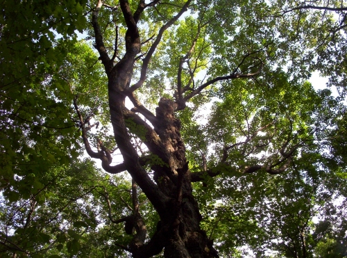
I was considering whether I should continue walking on to Deep Gap, another 2 miles, when I twisted my ankle and fell, despite having 2 walking sticks to prevent such things. That made the decision to camp in the ‘swag’ between the summits much easier. It is a very nice camp, with a soft, level place for a tent and a spring about a football field down the hill on the North Carolina side. Of course, there is also the ‘gnarly tree’ right there, too. I remember this conspicuous tree from my first trip through the ‘Snowbird’ section with the ‘Rat Patrol’, some 19 years ago, when we camped in the very same place. I always associate that tree with ‘gargoyles’—not only does it’s appearance seemingly make it a likely place for one to roost, but I vividly remember being ‘screamed’ at by a gargoyle-like sounding creature from the top of that tree in the darkness of the night many years ago.
I have heard stories that certain kinds of owls can make some rather creepy, disturbing noises, but in my mind, that will always be the ‘gargoyle tree’.
Fortunately, the night was quiet, peaceful, and gargoyle-less. I awoke, ready for a nice breakfast, only to discover that my camp-stove had ‘broken’ somehow. It had given me a few problems the night before, but that morning it would not even prime. That is how it is, when you least expect it, during the most embarrassing of moments, that is when someone appears, seemingly out of nowhere, to witness the inevitable meltdown as you cuss and threaten your stove…well, my stove, anyway. I was reminded of a fellow I had met many years ago at Trail Days–his name was ‘Stove-Stomper’–now I understand completely how someone can get that trail-name.
I didn’t actually stomp my stove, but eventually calmed down, broke down the camp, and began walking ‘north’ towards Max Patch. My pack still weighed more than it should have, and much of that weight was stuff that I could not even use, like my stove, the fuel bottle, and the rice and noodle dinners I had planned on eating. I tried not to think about how demoralizing it was, but the weight on my back would not let me forget.
I had planned on re-filling my water supply at Brown Gap (3 miles beyond Deep Gap) but as soon as I set a boot in the gap, a monsoon blew in, and I hastily set up a couple of tarps to stay dry under. It poured down the rain for over an hour. By the time it slackened, temporarily, I decided to camp right there in Brown Gap. Perhaps this gap should be re-named to ‘bad weather gap’, because I don’t remember ever a time when the weather wasn’t too cold, too hot, too windy, too snowy, or too wet in this place. I have camped there many times, being the place where the ‘Rat Patrol’ fed hungry hikers coming out of the Smokies every April for nearly 20 years. However, I hardly recognized the place, now that the tall pines are standing dead trees, obvious victims of the ‘pine-bark beetle’. All my favorite camp spots were either overgrown, buried under heavy, wet logs, or right beneath a stand of dead pines. I managed to get my tent set up before the next round of rain.
It rained all night.
The next morning was dark, and I barely had enough time to break down camp before the rains returned. Having mostly depleted my snack supply, since that was all I had to eat without a fire to cook on, and because the weather was not conducive to getting any views off of Max Patch anyway, I determined to walk back to the Standing Bear Farm a day early. In the back of my mind, I know I will be back, and will hike over Max Patch before autumn is over, already looking forward to another adventure in the Southern Appalachians.
There are only a couple of other day-hikes to mention here; a nice scouting hike on Unaka Mountain, as I checked out the newly relocated trail from Iron Mountain Gap. I really like the new switch-backed trail, and not having to climb over every high knob. The ATC and the Konnarock Crew really deserve a lot of credit for the planning and construction of the Appalachian Trail. I know how hard side-hill digging can be, and am aware of some of the dangers (a tree nearly fell on me during the Spivey Gap relocation), so the Trail Crews get my respect for their dedication and sacrifice.
Besides the Unaka section, there were pleasurable day-hikes over parts of Roan Mountain, Unaka Mountain (again), Holston Mountain, and Rich Mountain, taking photos of Red Fork Falls, Sill Branch Falls, and the ‘Blue Hole’ falls, along with more photos from the Roan High Knob and Sunset Rock (and any wildlife seen along the way). The last day-hike taken was a lazy loop hike up to the main ridgeline of Sampson Mountain, employing one ridge to ascend, and another ridge to descend, returning to the same meadow near Clark’s Creek.
I have some equipment to test, and supplies to gather, before the next mountain adventure, as I am determined to have a lighter, more streamlined, ‘stealth-pack’ before the ‘Rat Patrol Birthday Hike’, which is coming up soon.
Many thanks to the Web-Wizard for all the great work he does, keeping this site moving forward, and also to Lisa McClanahan for sending in the awesome photos of Colorado.
~~~~~~~~~~~~~~~~~~~~~Boulderman 8/28/2009