Conventional geologic theory suggests that the Appalachian Mountains were formed about 420 million years ago when two pre-historic continents crashed into each other, causing the crust of the earth to be splintered, folded and uplifted into what became the Appalachian Range. Some of the oldest mountains on the planet, the Appalachians used to be much taller, perhaps more than three times as high in elevation as they are today. One can only imagine how rugged, desolate and majestic this remarkable range of mountains once appeared.
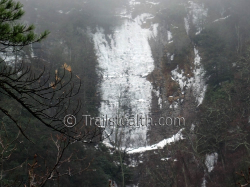
Likewise, it is difficult to comprehend what the ancient-complexions of specific places within the range itself must have once appeared, such as the phenomenal ‘Buckeye Falls’ on Rich Mountain, part of the Unaka Range. It is unimaginable to know just how tall and how sheer the cliff that these amazing waterfalls now navigate must have been like millions of years ago. Even today, at an estimated 600 feet tall, Buckeye Falls is technically the largest waterfall in North America east of the Rocky Mountains.
Situated within the reclusive Sampson Wilderness, Buckeye Falls is the most impressive, yet desolate, waterfall I have personally witnessed, and consider her (I always refer to waterfalls in a ‘feminine’ manner…) stunning and ‘untamable’. I have never heard who was the first person to ‘discover’ the immense cliff with falling water, or why ‘she’ is so inappropriately named, but I imagine Native Americans were most likely the first people to scout the deep hollow long before recorded history in North America. I cannot help but wonder what name these first Appalachians had for the cliffs. Perhaps they were regarded as ‘sacred’, which is what I like to think.
Fed by two springs near the top of Rich Mountain, that soon combine into one small stream, the colossal size of the sheer rock facing fairly dwarfs the size of the water source as it eventually ends up at the base of the falls. The enormous size of the rock-cliff at the base obstructs the view of the upper levels of the falls, so that the only complete view must be taken at a distance from one of the two immediate ridges that fork their way around the narrow, yet steep-sided mountain valley. I have, however, seen fairly good photos of the upper levels of the falls taken from a vantage point on Chigger Ridge (on Rich Mountain), but the ridges that wrap around the Buckeye hollow, like two talons on an giant eagles claw, apparently obscures the enormous rock wall which are the lower levels of the intriguing waterfall.
I have read that a good amount of the water actually becomes a vapor during the long, free-falling phases of the streams journey (there are several ledges where the water freefalls, between 50 and 75 feet at a time, that allow this water to vaporize into the air) and ends up at the base of the falls as a heavy mist instead of flowing water.
Caution should always be the first priority when visiting these dangerous falls. I do not recommend anyone to try to climb the cliff, because it is far too dangerous. That would be a really bad place to break a leg! Without ropes and heavy-duty climbing equipment, there are only two feasible routes, and that would be the ridge climb on either side of the falls, starting back at Clarks Creek, and not the falls themselves. Of course, you should expect these routes to be overgrown and very steep. During the winter season, beware of large chunks of ice falling from the cliff facing, which can also be hazardous. In the summer, of course, pay attention for snakes, bears and other wildlife.
Anyway, I first visited the falls during a ‘Rat Patrol Hiking Club’ adventure hike way back in 1987, and have had several more interesting adventures there since then, but none recently. Actually it has been 16 years since the last time I had seen the amazing waterfall, so I decided that I would hike out to Buckeye Falls—a 3 ½ mile trek—and climb the left ridge in an effort to get a view of the falls from there.
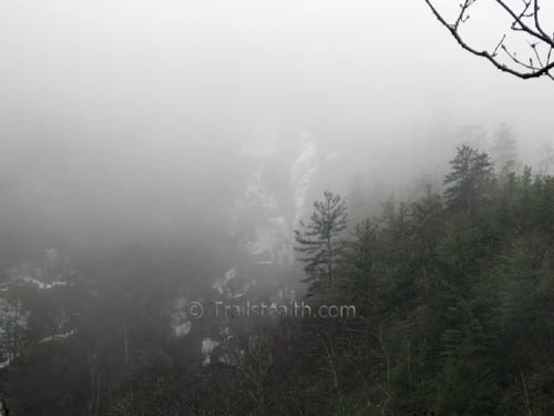
It was raining steadily almost all day, and the creek crossings were difficult to navigate as the creek is running fairly big right now, thanks to the recent melting snow and rain. I somehow managed to fall into Clarks Creek about a quarter mile before I reached the entrance to the Buckeye Hollow, so I was quite wet by the time I had climbed the ridge. The ridgeline was very steep, by-the-way, but I did eventually get a nice view of the ice-covered cliff-walls. As soon as I got there, however, a cloud moved down from the mist-enshrouded mountain tops and somewhat hid the upper levels of the waterfall in the dense fog. I also noticed that sound had a way of playing tricks with my ears on that side-ridge, where I thought I heard voices more than once, which is completely unexplainable.
The climb down the steep ridgeline was almost as brutal as the ascent, perhaps more-so, since it is easier to bruise a big toe while descending. By the time I returned to the Clarks Creek, my toes, and feet in general, were getting quite sore and my quadriceps and all the other ‘Gittyup and Go’,’Whoa Nellie’ and even the ‘Granny Gear’ –leg muscles were either smokin’ hot or leaking oil–maybe both. Anyway, it was kind of cold and my balance was a bit off kilter on the 3 ½ mile return hike, so I mostly just splashed my way across the creek-fords fairly quickly, knowing there was a dry pair of shoes waiting for me back at the trail-head.
In retrospect, after the cloud oozed down the mountainside and lingered in front of the upper levels of the waterfalls, it seemed to me like ‘Buckeye’, a totally inappropriate name for a waterfall so wild and untamable, is actually a shy, reclusive waterfall, still existing in relative solitude in among the ancient mountains of the Unaka Range. Even so, despite the cold and rain, I enjoyed my time viewing the somber waterfall, and considered the adventure a success.
There are only a couple other hikes to mention; a afternoon trek up Cliff Ridge on the Appalachian Trail, with nice views of the Nolichucky River, and an interesting snow-hike on Buffalo Mountain.
Many thanks to the Web-Wizard for adding the ‘Trail Stories’ pages back to the website, and for all the other website management there is to deal with. Also, for more ‘stealth-approved’ adventure blogs, check out Rat Patrol’s blog at Rattreks.com if you want to; he has been doing quite a lot of interesting waterfall and snow hikes lately.
More adventures soon, I hope…
~~~~~~~~~~~~~~~~~~~~~~~~Boulderman 3/2/2010


Awesome pics!!!! Great narrative. I just made it to the base of these falls last weekend myself with some help. No ice but LOTS of water stunning place. Thanks for sharing!!